My current summer plan is to solo kayak from the border of the Netherlands and Belgium to the most Northeastern point, which borders Germany. To do so would take about 15 to 20 days of continuous kayaking, assuming I can steadily maintain a pace of 40 to 50 kilometers per day. There are two routes possible; a shorter one that starts at sea, and deals with tides and shipping traffic, and a longer one that starts on a river and deals with inland shipping and locks.
Plan A – Cadzand to Nieuwe Statenzijl
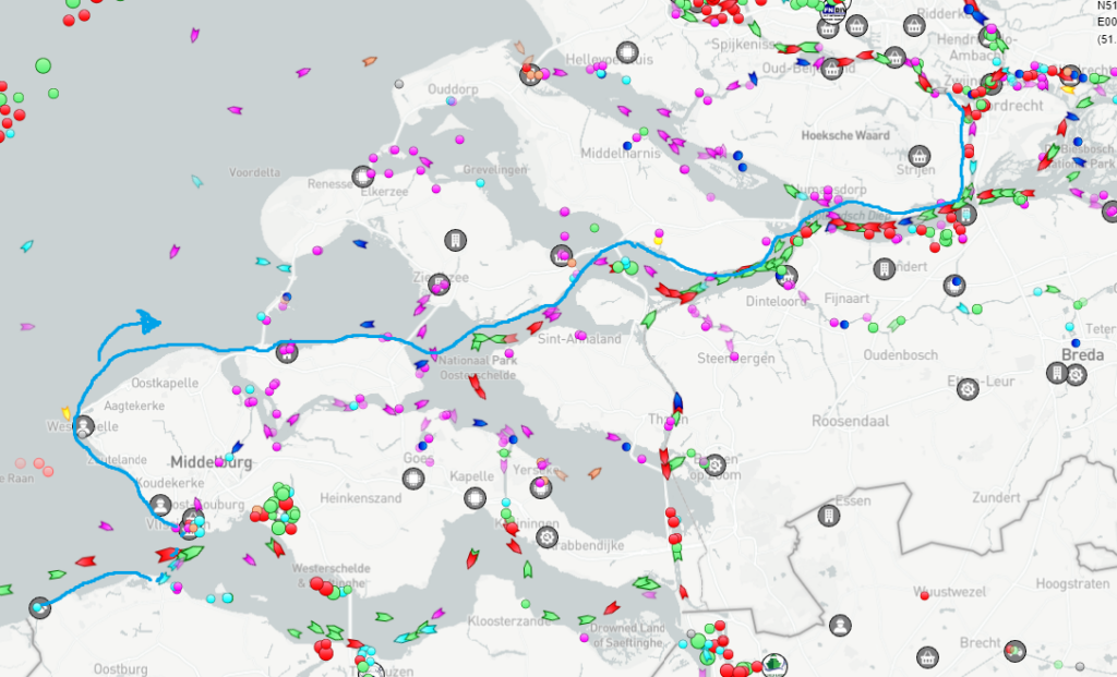
This trip will take me from Cadzand’s sunny beaches across the Westerschelde (by ferry – the only ferry I hope I will need to take due to the heavy shipping traffic on the Westerschelde) into the delta in Zeeland. From there, I hope to paddle upstream to the Biesbosch and move towards Rotterdam. Going through Rotterdam and on to Delft, I will turn north towards Leiden and Amsterdam. Once I pass through Amsterdam’s canals I’ll head for the wide, open waters of the Markermeer and IJsselmeer. Depending on conditions I can either try to paddle along the shore towards Ameland and finally Lauwersoog, or continue inland via the Frisian system of lakes and waterways. After a stop in Groningen – the club at which I learned how to paddle – I will continue towards Delfzijl onto the muddy banks of the Dollard. My goal will be to finish at Nieuw Statenzijl, on the border between The Netherlands and Germany.
Plan B – Maastricht to Nieuwe Statenzijl
Plan B is a safer alternative as it avoids solo paddling on the North Sea and navigating a couple of high-traffic areas. It starts at Maastricht and follows the Grensmaas (the “Pieterpeddel” canoe trail) for about a day, then goes downstream all the way down to the Biesbosch, where it joins the path from route A. Alternatively, this route can also continue from Nijmegen, cross the Waal and go upstream until Pannerden (another busy shipping river) and then take advantage of a beneficial stream from there on. It might even be possible to paddle 100km+ in a single day this way.
Comparing both options
A count of large vessels on the Meuse shows that there are around 50 large ships between Maastricht and Raamsdonksveer (~220 km) at any given moment, which is similar to the amount of large ships around the Hollandsch Diep and the Dordtsche Kil (30km) on a quiet day.
Compare the two maps with AIS data below, where pink vessels are pleasure craft, red are sea-going boats, green and cyan are inland vessels:

The western route (Route A)

And the eastern Route (B), note though that this route is on a separate river, isolated from traffic, until Roermond.
Route B is not without risks though longer, has more holiday-goers on small boats, and there are locks to navigate that may have to be taken together with longer ships.
Summing up
I estimate the total length of this trip will be somewhere around 600 to 700 kilometers. My normal touring pace is somewhere between 5 and 6 kilometers an hour if I take breaks into account, by all means this will be a slow adventure.
Apart from the starting and ending point no part of this route is set in stone. I can only depart on a calm day and some planning is required when tides are involved. However, I will plan each day ahead depending on the weather as I go. I intentionally start in the south because of the dominant wind direction being SW. Because there are so many factors at play it is hard to make a planning in advance.
Not all kayaking trips end the way they were supposed to. Usually there’s weather to take into consideration and I will probably need a couple of rest days. The risk of injury with kayaking is relatively high, but is mitigated by training and preparing properly. Still, I’d guess my chances of completing it are about 50:50.
I will make the final plans when I’m only a few days away from starting.
You might ask “why aren’t you going around the entire coastline?!” – as a sea kayaking rule we do not go out to sea with less than tree people. I’m already pushing it and don’t want to take risks that would seem reckless to any other (potential) sea kayaker out there. I’ve been paddling for about eight years, have obtained my zeevaardigheid, but I’m still a fairly inexperienced paddler when it comes to the sea. Not opting to follow the coast reduces the risks as well as exposing me to more environments and sights along the way. Furthermore, I’d have to cross a few ports that simply do not allow kayakers to pass.
Kayaking Gear and Costs
I have all of my gear sorted out, might do a write up on what I use to paddle around in the future. I’m only waiting on my VHF registration because that allows me to call for help and communicate with other boats. I expect to get it by the end of May and then we’re good to go.
Campsites in the Netherlands usually cost between 10 and 40 euros a night. Wild camping is rarely allowed and usually limited to islands, so not a viable alternative for a long trip through populated areas.
Long distance inspirations
There are a number of long-distance kayakers in the Netherlands. Most tend to prefer a low-profile but a couple of trips are documented on the internet:
- Axel Schroevers completed a 650 km solo trip around the Netherlands in 1994, and then did a 1241 kilometer trip together with Nico Middelkoop in 2003.
- Hans Nunnikhoven completed a number of long kayaking trips in the Netherlands between 2005 and 2008.
- Various other long distance paddlers have articles floating about, such as Leen Braber and Jan van der Velde who paddled down the Rhine river, Paul Thomassen (see his story in the book Kajakverhalen) who, amongs other trips, paddled from Prague to Noordwijk, and Jörgen van der Pol (who took down his website, but this blog remains) who paddled from Groningen to Moldova in order to raise money for a children’s hospital.

